Lockheed Martin Australia and Av-Comm have confirmed the successful installation of the first SouthPAN satellite dish, which will help improve the accuracy of GPS signals to as little as 10 centimetres.
The Southern Positioning Augmentation Network (SouthPAN) project aims to deliver Satellite Based Augmentation System (SBAS) services to Australia and New Zealand, providing improved positioning accuracy through a combination of reference stations, telecommunications infrastructure, computing centres, signal generators, and satellites.
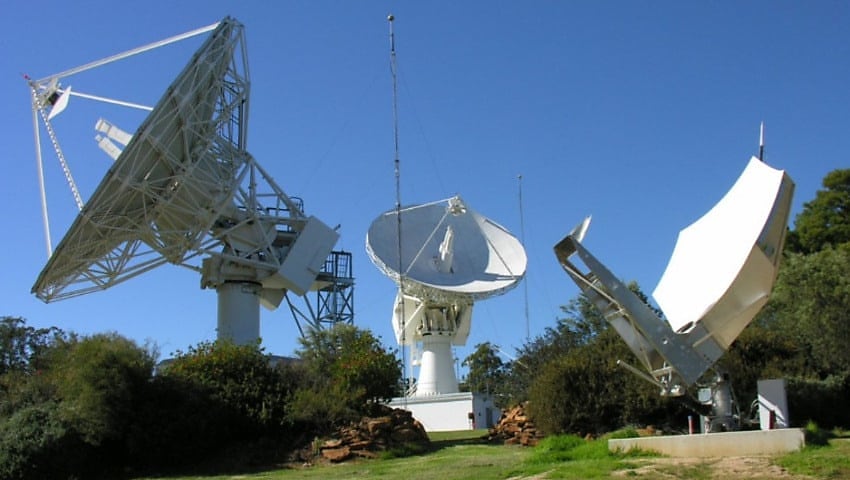
The recent announcement marks the completion of the first 11-metre satellite dish, alongside a control centre and dual radio frequency uplinks.
SouthPAN is expected to improve positioning accuracy from five to 10 meters to within 10 centimetres.
Lockheed Martin Australia was selected to work with Geoscience Australia and Toitū Te Whenua Land Information New Zealand as part of a $1.18 billion contract announcement in September 2022.
According to a Lockheed Martin Australia spokesperson, SouthPAN’s improved positioning accuracy will support Australian industry and emergency services providers.
“By enabling accuracy down to as little as 10 centimetres, we’re not just enhancing positioning services; we’re revolutionising how industries operate and how emergency services respond across the region,” Warren McDonald, chief executive of Lockheed Martin Australia and New Zealand, said.
NSW company Av-Comm was selected by Lockheed Martin Australia in December 2022 to oversee the creation of ground station uplink facilities for the SouthPAN project.
The project will not only support Australian industry, but will also prove Australian technology, Michael Cratt, AV-Comm’s managing director, explained.
“As a family-run Australian company, we’re not only contributing to the nation’s space sector but hopefully sparking innovation across industries dependent on precise positioning. It’s a step forward for Australian technology on the global stage.”
SouthPAN works by using a number of distributed ground stations to monitor signals broadcast by Global Navigation Satellite System (GNSS) satellites. It then compares each station’s known location with position data from the satellites.
“The GNSS signal data and measurement information is sent to correction processing facilities,” Geoscience Australia explained.
“The facilities aggregate the data from all ground stations, produce error corrections and status information about the GNSS satellites, and format the data in a standardised series of messages.”
“These messages are sent to an uplink station, which transmits data to a satellite in geostationary Earth orbit. The data is broadcast to all precise positioning users, who combine SouthPAN’s data with their own observations of GNSS satellites.”
Want to see more stories from trusted news sources?
Make Defence Connect a preferred news source on Google.
Click here to add Defence Connect as a preferred news source.
